LINK TO GAME
Going into this project, I knew I wanted to do something with writing systems again because it was one of the parts of the class that genuinely stuck with me.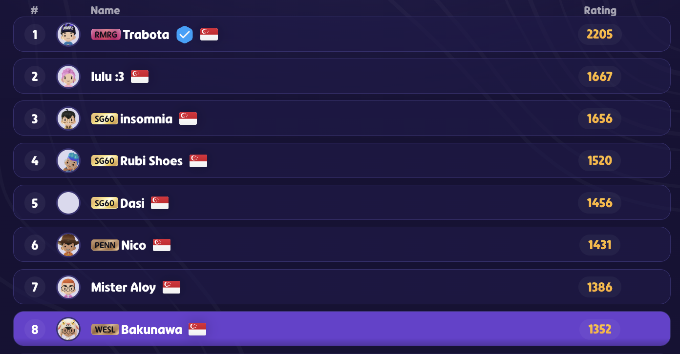 As someone extremely interested in languages, this topic seemed perfect for me. But just as important, I wanted to base it around something I actually enjoy – and for me, that’s GeoGuessr. I’ve spent a lot of time playing it just for fun, and I’ve always liked how it makes you pay attention to small details to figure out where you are. I’ve almost played it a little too much, as I am currently ranked #8 in Singapore! Fun fact! My brother chose the username “Bakunawa” as it is a mythical dragon from Filipino folklore!
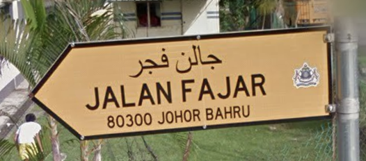 In terms of language specifically, I’ve learned a lot of strategies when it comes to recognizing what word means what on signs. Just a simple random example, but looking at streets in Malaysia, I’ve learned that “jalan” means “road”, meaning that when I see it, I won’t ever confuse it with a town name or some other word, despite me not knowing how to speak Malay. So choosing GeoGuessr wasn’t random – it felt like the perfect way to connect something I already loved with what we were learning in class.
For this project, the places that I focused on were Japan, South Korea, Taiwan, and Hong Kong (no China! I’ll get into that later). Going into the project, I wanted to see how different places with historical connections differed in writing styles in everyday modern life – like how they shape the visual identity of public spaces. Before this class, I didn’t think about this as much – I would see a sign and only think about what it said, not how the writing itself reflected history, modernization, or cultural identity. But throughout the course, we talked about how writing systems are not neutral – they shape the way societies organize language and even how people think about identity itself – which ultimately became the foundation of my project (Coulmas, 1989).
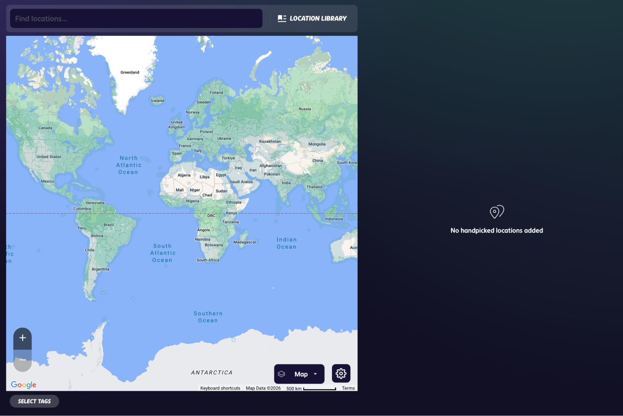 At the beginning of this project, though, I really underestimated how difficult the project would be. The method that I originally came into the project with was to basically open up a GeoGuessr map creator and just randomly find locations that matched my categories. The image on the right shows a blank project – this is what you’re greeted with when you create a new project in GeoGuessr. It’s just a blank map! As I began, I would spend huge amounts of time clicking a random place on the map trying to find different pieces of writing on transit stations, commercial streets, or signs that were actually useful for this project. Pretty quickly, I realized that approach was impossible to sustain. It was way too time-consuming, and most locations didn’t end up fitting what I needed. I was essentially searching blindly.
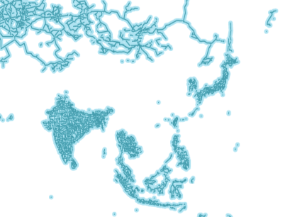 One of the biggest struggles was China. Originally, I wanted China (mainland) to be a major part of the project, especially because of how important Chinese characters were to this class as well as in East Asian writing systems historically. But I ran into a major limitation very quickly: there is almost no Google Street View coverage (the coverage that GeoGuessr uses) in mainland China. Since GeoGuessr relies heavily on Google Maps footage, it became extremely difficult to find consistent signage and usable locations there. The blue lines in the image represent the Google Street view coverage in the region (as of 2025) – notice there is almost nothing in mainland China! This changed the direction of my project. Instead of focusing on mainland China, I shifted more toward Taiwan and Hong Kong, where I could still analyze Chinese characters and public writing while actually having accessible street-level imagery to work with. This struggle ended up teaching me something important about both the project and the class material itself. Some of the themes that we had discussed in class this semester was about how political systems, modernization, and globalization shape communication and public space – and the lack of accessible mapping footage in mainland China reminds us that technology, information access, and visibility are also extremely political. Even this simple ability to “see” a place through digital maps is shaped by larger systems. I wasn’t expecting to run into this issue, since I thought there would be other non-Google coverage, but there was none, which then became part of how I thought about the project overall.
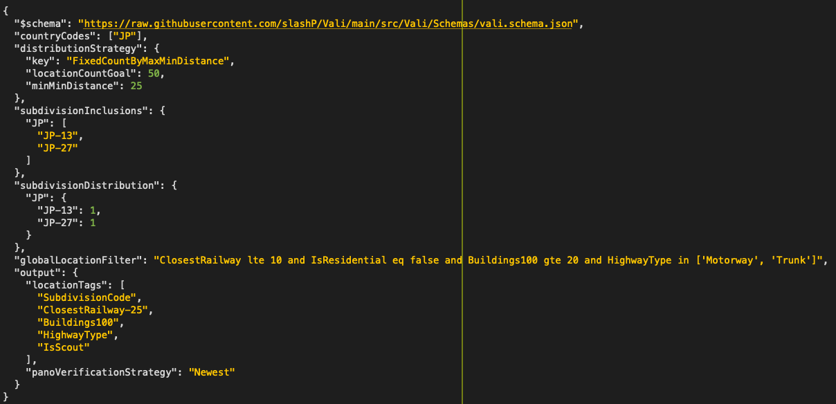 Because manually searching locations was so inefficient, I eventually decided to code a plugin (using json) to help generate locations for me. I’ve attached a screenshot of my code for Japan specifically, which I had to repeat for each country. The main thing I used it for was searching for locations near railways and metro stations in dense urban areas with lots of buildings and signage. I realized pretty early on that transit systems were some of the best places to study writing systems because they are designed to communicate quickly to huge numbers of people, including both locals and foreigners. Stations also naturally concentrate different kinds of text in one place: directional signs, advertisements, maps, business names, romanization, and symbols. This let me search for environments that were much more likely to contain the kinds of writing I wanted to analyze instead of wandering randomly through GeoGuessr for hours. But even with the plugin, though, I still had to manually proof check every location afterward. Even when the plugin would generate locations that technically match the conditions I was asking for, some did not actually contain meaningful signage, while others had the right kind of visual density but not enough linguistic variety to be useful for comparison.
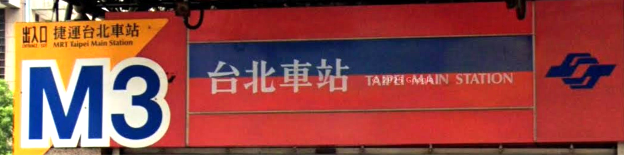 Now, I’d like to talk about a location from each country that I’ve included in my project, in order to understand their significance to this project. This first screenshot, from Taiwan, shows the entrance to the MRT Taipei Main Station. What stood out to me immediately was the use of traditional Chinese character of “車” rather than the simplified “车” – marking the space clearly independent from mainland China. At the same time, the sign also includes English: “MRT Taipei Main Station,” showing how transit signage has to balance local identity with international accessibility. However, the traditional Chinese characters visually dominate the sign, while the English functions more as a secondary accessibility layer. Because Taiwan continues using traditional characters instead of simplified ones, the sign also reflects larger historical and political differences within the Chinese-speaking world – further highlighting how writing systems act as products of modernization and state policy, with this sign becoming a really visible example of that idea (Yao, 2025).
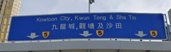 Next, I’ve put Hong Kong, which we haven’t explicitly talked about in this class, but I felt was very important due to its relations to China and its connection to traditional Chinese characters, like Taiwan. This screenshot shows a road sign pointing toward Kowloon City, Kwun Tong, and Sha Tin. Unlike the Taiwanese sign, English appears first, with traditional Chinese characters underneath. That ordering says a lot about Hong Kong’s history and identity. The sign reflects Hong Kong’s colonial past with the British, but also its present as a multilingual, globally connected city. The Chinese characters still root the sign locally, while the English makes the space accessible to international drivers and visitors. This was a useful contrast with Taiwan because both use traditional Chinese characters, but the visual hierarchy of English and Chinese is different – showing how the same writing system can take on different meanings depending on political and historical context.
The third screenshot, from Japan, shows a road sign with kanji, hiragana, route numbers, arrows, and romanized place names. This was one of my favorite examples because Japanese signage visually demonstrates how multiple writing systems operate together at the same time. The major place names like 神戸 (Kobe), 阿波座 (Awaza), and 十三 (Juso) are written in kanji, which is useful because kanji can communicate meaning very compactly and are easily recognizable to fluent readers. At the same time, the sign includes hiragana in “なにわ筋,” which is a road name. As we’ve talked about in class, hiragana appears softer and more phonetic compared to the denser visual structure of kanji, and its inclusion reflects how Japanese writing often mixes semantic and phonetic systems together within the same sentence or sign. Underneath many of the kanji place names are romanized versions like “Kobe” and “Juso”, which are clearly intended for non-Japanese readers and international drivers, especially in a large urban area like Osaka. What interested me is that the English does not replace the Japanese scripts like the previous examples in Taiwan and Hong Kong, but rather, it exists alongside them as a secondary layer of accessibility. From this sign alone, we can see connections to what we talked about in class, on Japan’s relationship with Chinese characters – adapting kanji from China, but over time developing hiragana and katakana to fit the grammatical and phonetic needs of Japanese (Holcombe, 2017).
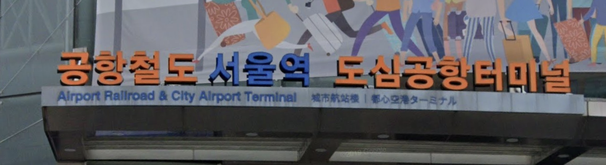 Finally, the screenshot that I’ve attached for South Korea shows a sign for Seoul Station’s Airport Railroad and City Airport Terminal. The most visually dominant text is written in Hangul, which visually, looks extremely different compared to the other writing systems in the project. Unlike the dense, square-like appearance of Chinese characters or the mixed visual texture of Japanese writing, Hangul appears much more modular and geometric because each syllable is constructed out of grouped phonetic letters. Even without understanding Korean, the script itself becomes an immediate visual marker of Korea. Underneath the Hangul, the sign includes English, Chinese characters, and Japanese katakana translations. Since this is an airport rail terminal connected to international travel, the multilingualism is practical and intentional, designed to guide tourists and travelers from multiple countries. But the hierarchy of the languages is important. Hangul is by far the largest and most visually dominant script on the sign, while the other languages appear in much smaller text underneath it. The English primarily functions for international accessibility, while the Chinese and Japanese reflect regional tourism and East Asia’s interconnected transit networks. What I found especially interesting is that the Korean text does not visually rely on Chinese characters at all, even though historically Korean writing was heavily influenced by them (and Hangul’s appearance and modular construction resonate). This connects to what we learned about Hangul as part of Korean modern identity – where Hangul was not just a writing system, but something tied to cultural pride and national identity (An, 2015). The sign reflects both globalization and national identity at the same time: it welcomes international movement through multilingual translations, but the visual center of the sign remains unmistakably Korean.
 Altogether, these explanations of some sample locations represent the kind of thinking I wanted players to do while moving through the map. The image here shows a map of all the locations I’ve included in the map – each language (Japanese, Korean, Traditional Chinese has a total of around 50 locations, hence the uneven spread you see in Japan. The signs are not just clues for guessing the country, but rather, they are small examples of how writing systems shape public space. Each location shows a different relationship between local identity, historical influence, modernization, and globalization. This was where the project connected most strongly to the class for me, where I was not just asking “Where am I?” in the GeoGuessr sense – I was asking why the space looked the way it did, why certain scripts appeared first, and what those choices revealed about the society behind the sign.
Lastly, I would like to talk about another part of the project that changed. Initially, I wanted to spend a lot more time analyzing universal symbols and iconography, as brought up by Professor Watanabe, but I quickly realized how difficult those were to find consistently. Unless you already know exactly where to look, finding those kinds of signs randomly is extremely hard. Instead, I focused more heavily on transit spaces, commercial streets, and public signage in general – as I’ve explained above. Looking back, I think that actually made the project stronger because it let me focus more deeply on writing systems themselves instead of trying to cover too many ideas at once.
 Overall, I think the biggest thing this project taught me is that writing systems are much more embedded into everyday life than I realized before taking this class. I used to look at signs mainly for information (not just in GeoGuessr), but now I notice the structure of the writing itself, the order of languages, and the choices behind what appears visually dominant. Working on this project made me realize that even something as ordinary as a transit sign reflects history, politics, modernization, and cultural identity. I also think this project changed the way I interact with GeoGuessr itself. Before, I mostly treated signs as clues to identify a location as quickly as possible. But while working on this project, I started slowing down and actually thinking about why spaces look the way they do – which reflects the biggest thing I learned from this project and the class overall: writing systems are not just tools for communication, but systems shaped by history and society. What made this project especially meaningful to me was that it connected academic ideas from class to something I genuinely enjoy. Despite it being extremely time consuming, I had lots of fun! Instead of feeling disconnected from my own interests, the course material became something I could actively explore through a hobby I already spent a lot of time with. I think that made me much more invested in the project, and honestly, it made me appreciate GeoGuessr, as well as the study of writing systems in a completely different way. I hope you enjoy playing my GeoGuessr map, and that you notice some new things in regards to writing systems (or maybe even something unrelated to my project) in everyday modern life throughout these East Asian countries!
Works Cited
An, Yelee. Generality and Distinctiveness of Korean Language Modernization. 2015.
Coulmas, Florian. The Writing Systems of the World. Jan. 1991.
Holcombe, Charles. A History of East Asia: From the Origins of Civilization to the Twenty-First Century. 2d. ed, Cambridge University Press, 2017.
Yao, Zhicheng. “Chinese Characters and Cultural Identity: A Cultural Interpretation from ‘Standardization of the Writing System’ to Modern Script Reforms.” Journal of Education, vol. 57, 2025.